June 10, 2026
Geophysical survey is one of the most effective ways to assess archaeological potential at an early stage. It helps developers understand what may survive below ground, target further investigation where it is really needed, and support informed planning decisions without unnecessary disturbance.
What is a geophysical survey?
A geophysical survey is a non-intrusive way of investigating what may lie beneath the ground surface. In archaeological terms, it uses specialist instruments to detect contrasts in the physical properties of soils, deposits and buried remains. That means it can identify patterns that may indicate archaeological features such as ditches, pits, walls, foundations, hearths or former land surfaces, without the need to excavate first.
For developers, the main advantage is speed. A survey can assess relatively large areas efficiently and provide an early indication of where archaeological constraints may exist across a site.
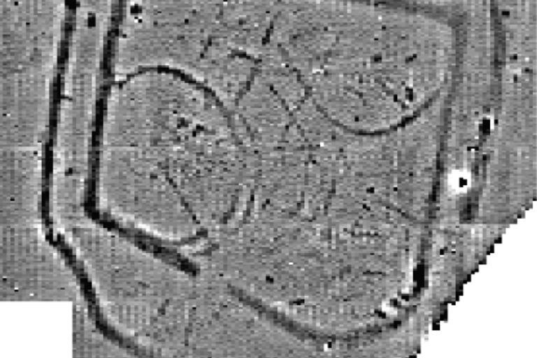
How does it work?
Different techniques measure different properties in the ground. The most commonly used methods in archaeological work are magnetometry, earth resistance survey and Ground Penetrating Radar (GPR). Each has strengths and limitations, and the right choice depends on the nature of the site, the expected archaeology, geology, ground conditions and the questions being asked.
Magnetometry is often used to identify features such as infilled ditches, pits, kilns or areas affected by burning. Earth resistance survey can be particularly effective where buried masonry or compacted surfaces are expected. GPR can help build a more layered picture of subsurface remains and is sometimes useful for identifying depth, form and complexity.
In practice, the best results often come from selecting the method or combination of methods most appropriate to the site rather than relying on a single technique as a universal solution.
What can geophysical survey tell us about archaeological potential?
Geophysical survey helps assess whether a site is likely to contain buried archaeological remains and, crucially, where those remains may be concentrated. This makes it a valuable tool for understanding archaeological potential before designs are fixed or intrusive work begins.
Depending on the site and conditions, survey results may indicate the presence, character, extent and layout of archaeological features. In some cases, they can also suggest relationships between features or hint at different phases of activity. For example, a survey might reveal enclosure ditches, settlement patterns, trackways, industrial features or evidence for former field systems.
Just as importantly, geophysical survey can help identify areas where there is little or no detectable response, which can be useful when refining development layouts or targeting evaluation trenching. However, it is not a guarantee that archaeology is absent. Some remains do not produce a clear signal, and factors such as modern disturbance, geology, made ground, services, vegetation or waterlogged conditions can affect results.
In other words, geophysics is a powerful decision-support tool, not a standalone answer. It reduces uncertainty, but it usually works best alongside desk-based research, site inspection and, where needed, targeted intrusive evaluation.
Why does it matter in the planning process?
In England, archaeology is a material consideration in planning decisions, and local planning authorities need enough information to understand the significance of heritage assets and the potential effect of development on them. National planning policy expects applicants to provide proportionate information so that decisions are informed rather than reactive. Historic England explains that archaeology should be considered through the planning process, while the National Planning Policy Framework (NPPF) requires applicants to describe the significance of affected heritage assets to a level proportionate to their importance.
This is where geophysical survey often comes in. If a site has archaeological potential, a planning archaeologist may recommend geophysical survey as part of the evidence base for an application, particularly where non-intrusive assessment is appropriate. The Chartered Institute for Archaeologists notes that geophysical survey can inform the presence or absence, character and extent of buried archaeology as far as reasonably possible, including in response to proposed development and as part of the planning process.
Used early, it can help developers understand constraints, programme further work in a targeted way, and reduce the risk of costly surprises later in determination or construction. It can also support more efficient scheme design by showing where archaeological sensitivity may be highest and where impacts might be avoided, reduced or managed.
What geophysical survey can and cannot do
Geophysical survey can:
- provide an early, non-intrusive indication of buried archaeological remains
- identify patterns and concentrations that help define archaeological potential across a site
- inform risk management, design development and targeted follow-up work
- support proportionate evidence gathering for planning
Geophysical survey cannot:
- detect every type of archaeology in every set of ground conditions
- replace archaeological judgement or, where required, intrusive evaluation
- confirm significance on its own in every case
- remove the need for a wider heritage strategy
A practical takeaway for developers
For sites with known or suspected archaeological potential, geophysical survey is often one of the quickest and most cost-effective ways to build a clearer evidence base early in the process. Commissioned at the right stage and designed for the specific site, it can help developers make better-informed decisions, engage constructively with planning archaeologists and avoid unnecessary delay later on.